Kosen Studio Ltd
Object 005 UK Peak Collection — Engraved Mountain Cards
Object 005 UK Peak Collection — Engraved Mountain Cards
Couldn't load pickup availability
UK Peak Collection — Engraved Mountain Cards
A pocket-sized collection of Britain’s mountains.
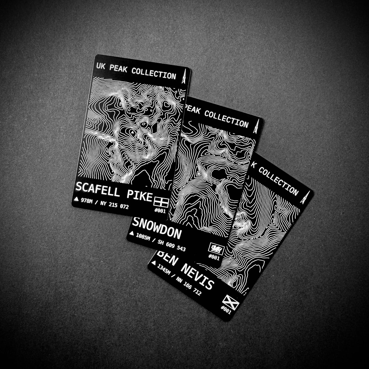
Choose any UK mountain and we’ll create its card using Ordnance Survey terrain data, with detailed contours centred on the summit and permanently engraved into black anodised aluminium.
Each card records the mountain name, summit height, Ordnance Survey grid reference, national flag and its numbered place by height within England, Scotland or Wales.
At just 85.6 × 54 mm — the size of a standard bank card — they’re an affordable little record of the mountains you’ve climbed, the ones that mean something to you, or the peaks you simply want to collect.
The summit-centred contours give every mountain its own distinctive topographic fingerprint.
Each card is supplied in a 35-point, acid-free, yellowing-resistant collector’s card sleeve to protect it when stored or displayed.
£4.99 each or any 3 for £12.
Details
• Choose any UK mountain
• Black anodised aluminium
• 85.6 × 54 × 0.4 mm
• Summit-centred contours created from Ordnance Survey terrain data
• Mountain name engraved as requested
• Summit height
• OS grid reference
• National flag
• Height ranking within England, Scotland or Wales
• Standard Ordnance Survey data attribution engraved on the reverse
• Supplied in a 35-point, acid-free, yellowing-resistant collector’s card sleeve
• Lightweight, slim and easy to keep or display
• Designed and engraved in the UK
Ordering
For a single card, enter the mountain name in the text box exactly as you would like it to appear on the card.
Where a mountain has more than one commonly used name, the choice is yours. For example, enter Snowdon if you want Snowdon engraved, or Yr Wyddfa if you want Yr Wyddfa engraved.
For the 3 for £12 offer, select Buy 3 and enter all three mountain names in the text box, separated by commas.
For example: Ben Nevis, Scafell Pike, Yr Wyddfa
You can choose three different mountains or multiple cards of the same mountain.
Please check your chosen spelling carefully, as the mountain name will be engraved as requested.
Data & Attribution
Topographic contours are created using Ordnance Survey Terrain 50 data.
Mountain names, heights, grid references and classification data are derived from The Database of British and Irish Hills v18.5, licensed under Creative Commons Attribution 4.0 International (CC BY 4.0). Data has been adapted for the UK Peak Collection.
Contains OS data © Crown copyright and database right 2026.
Please Note
This listing is for the standard UK Peak Collection card. The reverse carries the required Ordnance Survey data attribution and is not personalised with your summit climb date or message.
Please see our separate listing for custom reverse options. (coming soon)
Share